
Weather maps Archives

weather maps Archives
About the Surface Archive
Recent United States (CONUS) Analyses | ||
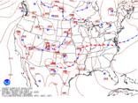 (No observations, color)Latest image (No observations, color)Latest imageLoop: [3] [7] Days | 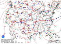 (With observations, color)Latest image (With observations, color)Latest imageLoop: [3] [7] Days | 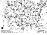 (With observations, B&W)Latest image (With observations, B&W)Latest imageLoop: [3] [7] Days |
Earliest available map is from March 29, 2006 at 18 UTC
Recent North American Analyses | ||
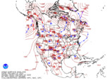 (No observations, color)Latest image (No observations, color)Latest imageLoop: [3] [7] Days |  (IR Satellite Imagery)Latest image (IR Satellite Imagery)Latest imageLoop: [3] [7] Days | |
Earliest available map for the zoom-in analysis is May 1, 2005 at 00 UTC
Earliest available map for the other North American analyses is March 29, 2006 at 18 UTC
Historical Archive of North American Analyses |
Links to Archived Weather Data
NOTE: Most of the links below are intended for meteorological research purposes, and may not always be available. For official weather and climate records, visit the National Climatic Data Center.
Starting points
MMM image archive This is probably the best "one-stop shop" for looking at archived images. It includes radar composites, satellite images, soundings, surface and upper-air maps, and much more.
SPC severe events archive This is another good place to get started with surface and upper air analyses, soundings, etc.
CSU-Atmos archive Has archives of what used to be "DIFAX" maps, such as NCEP surface and upper-air analyses
For GEMPAK users: Iowa State GEMPAK archive This is an outstanding archive of data in GEMPAK format, including model analyses and forecasts, surface and upper air data, and more. It also does have a few archived images for quick looks.
Surface data
MesoWest Outstanding real-time and archived surface observations from both standard sources and the various mesonets around the country. Contains a wealth of archived observations that can be easily plotted via their web interface.
Plymouth State Allows you to create your own surface charts.
NCAR/RAP Plotted surface maps, they keep about the past week on their site.
Soundings
Wyoming Comprehensive sounding archive, goes back to the 1970s.
NCDC Integrated Global Radiosonde Archive Long-term sounding archive in text format.
Upper-air
Plymouth State Plot your own upper-air maps.
Dynamic Tropopause maps--Albany Real-time and archived DT maps, and you can create nice animations.
Wind profilers
NOAA profiler network Has an archive of wind profiler data over the US.
Radar
Iowa Environmental Mesonet RadMap Make your own radar mosaic maps including custom overlays
NCAR/RAP Archived radar goes back about a week.
NSSL/OU Q2 Post-processed radar data archive, along with quantitative precipitation estimates.
Plymouth State
NCDC NEXRAD inventory If you want the actual data (rather than just images), this is where to get them. Full level 2 and level 3 data.
WSI NOWRad composite data These are 2-km, 15-minute radar composites for the entire US. Download the data and create your own plots (easiest using GEMPAK.)
Satellite
NOAA CLASS Archived satellite data from both geostationary and polar-orbiting satellites.
CSU/CIRA Archived GOES satellite images going back four weeks.
Model analyses and forecasts
NCDC NOMADS This is the repository for archived model analyses and forecasts from the NCEP models. You can make some simple plots right from the web page, or download the data (GRIB format).
CSU On our site with real-time weather data, we also maintain an archive of model forecast images going back several weeks. Just click on any of the images, and there is a menu for "previous runs" on the left-hand side that you can use to choose a previous model run.
ARM archive The ARM program has some archived RUC analyses...you'll need to get an account (free), and then you want to look for files called "sgpallruc*" for the dates you're looking for. These are in netCDF format, so they might be the way to go if you prefer that format.
North American Regional Reanalysis Reanalysis that goes back to 1979. 3-hour time resolution, 32-km spatial resolution over North America.
TIGGE archive TIGGE is the THORPEX Interactive Grand Global Ensemble. It has archived ensemble forecasts from several centers around the world, with data going back to late 2006.
Misc.
SPC mesoanalysis archive Archive of SPC's objective analysis--only has the full country images in the archive, rather than the individual subregions.
NWS text product archive Download archived text products (i.e., forecast discussions, zone forecasts, warnings, etc.)
NWS QPE Plots of quantitative precipitation estimates using gauge and radar data.
Stage IV precip data This is what goes into the above images, but here you can download the hourly data (GRIB format.)
Iowa Environmental Mesonet "Cow" Provides (unofficial) archive of National Weather Service storm-based warnings and how they verified.
Records of the Weather Bureau
(Record Group 27)
1735-1979
Overview of Records Locations
Table of Contents
- 27.1 Administrative History
- 27.2 Meteorological Records of the Surgeon General's Office 1819-1916
- 27.3 Records of the Smithsonian Meteorological Project 1848-91
- 27.4 Records of Signal Corps Meteorological Work 1859-97
- 27.4.1 Correspondence
- 27.4.2 Administrative records
- 27.4.3 Records of observations
- 27.4.4 Records of compilations
- 27.4.5 Records of the Lady Franklin Bay Expedition, 1881-84
- 27.4.6 Records of the International Polar Expedition to Point Barrow, AK
- 27.5 Records of the Weather Bureau 1792-1965
- 27.5.1 Records of the Office of the Chief of the Weather Bureau
- 27.5.2 Administrative records
- 27.5.3 Records of the Climatology Division
- 27.5.4 Records of the Solar Radiation Investigation Division
- 27.5.5 Records of the Marine Division
- 27.5.6 Records of the Division of Operations and Reports
- 27.5.7 Records of the Division of Station Facilities and Meteorological Observations and its predecessors
- 27.5.8 Records of the Office of Meteorological Research
- 27.5.9 Records of the Forecast Division
- 27.5.10 Records of the Division of Synoptic Reports and Forecasts
- 27.5.11 Records of the Division of Hydrologic Services and its predecessors
- 27.5.12 Records of the Statistics Division
- 27.5.13 Records of the Aerological Division
- 27.5.14 Records relating to the Polar Operations Project
- 27.5.15 Other records
- 27.6 Records of Field Operations 1735-1979
- 27.6.1 Records of the Eastern Region
- 27.6.2 Records of the Central Region
- 27.6.3 Records of the Western Region
- 27.7 Textual Records (General) 1876-1972
- 27.8 Cartographic Records (General) 1873-1960
- 27.9 Motion Pictures (General)
- 27.10 Still Pictures (General) 1880-1950
27.1 Administrative History
Established: In the Department of Agriculture by an act of October 1, 1890 (26 Stat. 653).
Predecessor Agencies:- Smithsonian Institution (meteorological functions, 1847-70)
- Office of the Surgeon General (meteorological functions, 1818-70)
- Office of the Chief Signal Officer (meteorological functions, 1870-90)
Transfers: To the Department of Commerce by Reorganization Plan No. IV of 1940, effective June 30, 1940; to the Environmental Science Services Administration, Department of Commerce, by Reorganization Plan No. 2 of 1965, effective July 13, 1965; to the National Oceanic and Atmospheric Administration, Department of Commerce, by Reorganization Plan No. 4 of 1970, effective October 3, 1970.
Functions: Provided basic weather service in support of federal agencies and the general public, including weather forecasting and collecting, and disseminating temperature, rainfall, and climatic data for the United States.
Abolished: By Department of Commerce Organization Order 25-5A, effective October 9, 1970.
Successor Agencies: National Weather Service, National Oceanic and Atmospheric Administration, Department of Commerce.
Finding Aids: Harold T. Pinkett, Helen T. Finneran, and Katherine H. Davidson, comps., Preliminary Inventory of the Climatological and Hydrological Records of the Weather Bureau, PI 38 (1952); Helen T. Finneran, comp., Preliminary Inventory of the Operational and Miscellaneous Meteorological Records of the Weather Bureau, NC 3 (1965); Lewis J. Darter, Jr., comp., List of Climatological Records in the National Archives, SL 1 (1942, reprinted 1981).
Related Records:Record copies of publications of the Weather Bureau in RG 287, Publications of the U.S. Government.
Records of the Office of the Secretary of Agriculture, RG 16.
Records of the Hydrographic Office, RG 37.
Records of the U.S. Naval Observatory, RG 78.
Records of the Office of the Chief Signal Officer, RG 111.
Records of the Office of the Surgeon General (Army), RG 112.
Records of the National Oceanic and Atmospheric Administration, RG 370.
The Weather Bureau's basic climatological records of surface, land, and air observations since 1872 and its principal records of marine observations since 1904 are in the National Climatic Data Center (formerly the National Weather Records Center), Asheville, NC.
27.2 Meteorological Records of the Surgeon General's Office
1819-1916
History: The first nationwide weather system of the Federal Government was inaugurated in 1814 when army hospital, post, and regimental surgeons were directed to keep diaries of the weather. After the establishment of a weather service in the Signal Office in 1870, the meteorological work of the Surgeon General's Office was gradually discontinued. Post surgeons continued to submit monthly weather reports, on a voluntary basis, to the Surgeon General's Office, the Signal Office, and, after 1891, to the Weather Bureau.
Textual Records: Records from military posts, including hourly observations made at equinoxes and solstices, 1819-1916; daily meteorological observations of post surgeons, 1819-1916; and monthly summaries of meteorology, 1819-86. Barometrical registers, 1855-68, 1876-86. Psychrometrical registers, 1874-77. Records of army posts in California, 1843-68.
Related Records: For a microfilm copy of meteorological reports received from army surgeons at military posts, 1819-59, see 27.5.7.
27.3 Records of the Smithsonian Meteorological Project
1848-91
History: In 1847, under the leadership of its first secretary and director, Joseph Henry, the Smithsonian Institution began collecting records of meteorological observations and started a system of obtaining weather data from voluntary observers throughout the country. The services of these observers were transferred to the weather service of the Signal Corps in 1873.
Textual Records: Letters received, 1848-57, 1859-67. Letters sent, 1850-53. Records of observations made at the Smithsonian Institution, 1858-74. Meteorological observations of the U.S. Coast Survey, 1853-90. Miscellaneous meteorological material accumulated by the Smithsonian, 1848-91.
Microfilm Publications: M1379.
Related Records: For a microfilm copy of meteorological reports from voluntary observers, 1840-73, see 27.5.7.
27.4 Records of Signal Corps Meteorological Work
1859-97
History: The meteorological service of the Signal Corps was established by an act of February 9, 1870 (16 Stat. 369), authorizing a system of regular weather reporting stations; formally assigned to the Signal Corps by War Department General Order 29, March 15, 1870. In 1873, services of the Smithsonian Institution's voluntary observers were transferred to the Signal Corps, and beginning in 1874, meteorological reports received from military posts were submitted to the Chief Signal Officer. In 1874, the Smithsonian's collection of meteorological reports was transferred to the Signal Office with the approval of the Secretary of War. The meteorological activities of the Signal Corps were transferred to the Weather Bureau in 1890.
27.4.1 Correspondence
Textual Records: Letters sent, 1870-97, and received, 1870-94. Observers' letters sent and received, 1872-93. Voluntary observers' letters sent, 1874-84, and received, 1874-84, 1888-93. Letters received from the State Weather Service, 1891-94. Letters sent from and registers of letters received at Concho, TX; Fort Gibson, Indian Territory; and Grierson Springs, TX, 1873-87 (in Fort Worth).
27.4.2 Administrative records
Textual Records: Rosters of officers, enlisted men, and civilians employed at the Signal Office, 1868-81. Records relating to enlisted men, 1881-90. Officers' record book, n.d. Proceedings of the board for examination of enlisted men, 1880-86. Order books, 1870-84. Reports of meetings of the General Board of Assistants, 1881-84. Records concerning the transfer of meteorological functions to the Agriculture Department, 1887.
27.4.3 Records of observations
Textual Records: Meteorological records transferred to Signal Corps from observers for the Survey of the Northern and Northwestern Lakes, 1859-76. Weekly meteorological reports, 1870-81. Records of international simultaneous observations, 1874-92. Reports of rainfall stations, 1887-88. Journals of weather stations in Texas, 1877-83 (in Fort Worth). Summaries of meteorological observations at Middletown, CT, 1875-76 (in Boston). Meteorological observations at Macon, GA, 1873-82 (in Atlanta); Montgomery, AL, 1876-81; and Pikes Peak and Colorado Springs, CO, 1882-83 (in Denver). Records of experimental self-registering instruments, 1870-88.
Microfilm Publications: M1379.
Related Records: For microfilm copies of meteorological reports from regular stations, 1870-90, and regular and voluntary observers, 1874-90, see 27.5.7.
Maps: Observations by Western Union Telegraph Company, 1870 (13 items); and by Cleveland Abbe, 1870-71 (80 items). Manuscript and published Signal Service daily weather maps of the United States, 1872-86 (26,000 items). Tri-daily weather maps, 1874-88 (1,035 items). Wind, cloud, rain, precipitation, and barometric pressure, 1871-91 (171 items). International polar projection, 1877-86 (3,760 items). North Atlantic ocean weather, 1888-90 (1,470 items). Storm tracks, 1864-86 (240 items). Maps received from field offices, 1871-91 (195 items). See also 27.7.
27.4.4 Records of compilations
Textual Records: Monthly meteorological means, totals, and summaries, 1883-90. Abstracts of reports of voluntary observers and army post surgeons, 1874-86. Temperature and precipitation data, 1880-86. Reports of wind, 1872-79; rainfall, 1871-84; barometric pressure, 1871-90; and temperature, 1871-86.
27.4.5 Records of the Lady Franklin Bay Expedition, 1881-84
History: Scientific and exploratory expedition to area of Lady Franklin Bay, Greenland, authorized by act of May 1, 1880 (21 Stat. 82). Marooned, winter of 1883-84. Survivors rescued, June 22, 1884.
Textual Records: Manuscript and published reports, 1886-88. Journals and diaries, 1881-85. Subsistence records, 1881-85. Scientific data, 1881-83. Letters received, 1881-83. Correspondence with and about expedition members, 1884-86. Records relating to the 1882 and 1883 relief expeditions, 1883-85.
Microfilm Publications: T298.
Maps and Charts: U.S. temperatures, 1881. Isobars from international polar observations, 1883. Arctic areas, including Greenland, Kane Basin, and Lady Franklin Bay, 1881-85 (59 items). See also 27.7.
Photographs: Views of Fort Conger, Lady Franklin Bay, expedition members, equipment, supplies, camp scenes, ice conditions, and scenery, 1881-83 (53 images). See also 27.10.
Sketches: Animal life, ice formations, and scenes observed by expedition members while on sledging expeditions, 1881-83; and Greenland coast by W.M. Beebe aboard the USS Neptune while on relief mission, 1882-83 (45 images). See also 27.10.
Related Records: Additional materials on the Lady Franklin Bay Expedition among the papers of David Legge Brainard ("Brainard Collection") in National Archives collection of donated materials.
Subject Access Terms: Greeley, Aldolphus Washington.
27.4.6 Records of the International Polar Expedition to Point
Barrow, AK
History: By War Department Special Order 102, June 24, 1881, an expeditionary force to Point Barrow, Alaska Territory, was organized under the command of Lt. P. Henry Ray, 8th Infantry.
Textual Records: Register of letters received, 1881-83. Letters sent, 1881-83. Morning reports, 1881-83. Expedition journal, July-September 1881, August-October 1883. Daily meteorological record, 1881-83. Thermometer and wind records, and barometer and galvanometer readings, 1881-83. Observations of magnetic variations, 1881-82. Aurora and tide records, 1881-83.
Photographs: Arctic animals, natives, geological features, ice conditions, and native villages, 1881-83 (28 images). See also 27.10.
27.5 Records of the Weather Bureau
1792-1965
27.5.1 Records of the Office of the Chief of the Weather Bureau
Textual Records: Letters sent, 1891-1911. Letters received, 1894- 1912 (855 ft.), with registers, 1894-1911, and indexes, 1892- 1906. General correspondence, 1912-65. Records of Weather Bureau Chief Francis Wilton Reichelderfer, including personal memorandums on aerological matters, 1924-29; war project weekly reports, 1942-45; correspondence, 1939-63; desk files, 1939-53; subject files, 1934-63; and miscellaneous records, 1938-47.
Subject Access Terms: American Association of Weather Forecasters; American Geophysical Union; American Meteorological Society; Institute of Aeronautical Sciences; International Geophysical Year; National Academy of Sciences; National Advisory Committee for Aeronautics.
27.5.2 Administrative records
Textual Records: Records of the Budget Office, 1925-65. Records of the Administrative Operations Division, including correspondence, 1941-53; and directives, 1940-47, 1959. Station inspection reports, 1871-1930. Records describing weather stations, 1883-1904. Annual reports of stations, 1888-96. Rosters and directories of commissioned personnel, 1901-60.
Maps: Locations of facilities, stations, and administrative districts, 1922-48 (31 items). See also 27.7.
Architectural and Engineering Plans: Building plans of Weather Bureau stations, 1894-96 (280 items). See also 27.7.
27.5.3 Records of the Climatology Division
Textual Records: Reports of observers in cotton regions, 1883-1902; and corn and wheat regions, 1896-1902. Snowfall bulletins, 1897-1904. Daily journals and abstracts, 1870-1907.
Maps:Weather Crop Bulletin, 1891-95 (150 items). Climate and Crop Bulletin, 1896-1907 (384 items). National Monthly Weather Bulletin, 1908-14 (224 items). Dates for seeding and harvesting, ca. 1893 (15 items). U.S. climatic charts, 1870-1901 (26 items). Snow charts, 1892-96 (69 items). Snow and ice bulletins, 1893-1919 (448 items). Frost and growing season, 1911 (5 items). Normal surface wind, 1942 (18 items). Thunderstorms, 1952 (1 item). Sunshine hours, 1955 (1 item). Climatological atlas of the North and South Pacific, 1959-61 (140 items). See also 27.7.
27.5.4 Records of the Solar Radiation Investigation Division
Textual Records: Solar and sky radiation measurements, 1908-41.
27.5.5 Records of the Marine Division
Textual Records: Abstracts of ships' logs collected by Lt. Matthew Fontaine Maury ("Maury Logs"), 1796-1861. Abstracts of ships' logs, 1862-78. Records of marine observations by ocean square, 1873-86; and simultaneous meteorological observations on ships, 1886-1902. Ship abstract storm logs, 1896-1910. Gale and storm reports, 1895-1910. Fog reports, 1896-1910. Marine meteorological journals, 1879-93. Records containing summary weather data for the North Pacific and North Atlantic Oceans, 1890-1904. Records of observations at the Guam Naval Station, 1902-8, 1913-19 (in San Francisco). Records of observations in the Gulf of Mexico and North Atlantic and North Pacific Ocean areas, 1890-1930; and the Azores Islands, 1896-99, 1912-21.
Microfilm Publications: M1160.
27.5.6 Records of the Division of Operations and Reports
Maps: Marine Section monthly maps of climatic conditions in the oceans and Great Lakes, 1909-14 (855 items). See 27.7.
27.5.7 Records of the Division of Station Facilities and
Meteorological Observations and its predecessors
Textual Records: Microfilm copy of a compilation of meteorological reports, 1819-92 (562 rolls), arranged by state and thereunder alphabetically by station, consisting of reports of army surgeons at military posts, 1819-59; Smithsonian Institution voluntary observers, 1840-73; and regular stations and voluntary observers of the Signal Office and Weather Bureau, 1870-92. Daily observations of meteorology at military posts ("Meteorological Registers"), 1819-1916. Journals of daily observations at the Naval Observatory, Washington, DC, 1842-1913. Reports of wind movement, 1872-1904. Reports of wind direction, 1891-1904. Annual station reports, 1888-96. Monthly station reports, 1905-7. Meteorological observations at Mount Washington, NH, 1889-92 (in Boston); Brownsville, TX, 1889-92 (in Fort Worth); and Mount Weather, VA, 1905-14 (in Philadelphia). Summaries of meteorological observations at Woods Hole, MA, 1873-95 (in Boston). Storm warnings, Ludington, MI, 1916 (in Chicago). Missouri precipitation summaries, 1856-1904 (in Kansas City). Observations in Alaska, 1881-92, 1898-1920 (in Anchorage). Reports of observations of Halley's Comet, 1910.
Microfilm Publications: T907.
Maps: Locations of weather reporting stations, forecast centers, flight advisory weather service units, airport stations, and headquarters, 1944-45 (10 items). See also 27.7.
27.5.8 Records of the Office of Meteorological Research
Textual Records: Records, 1953-60, relating to the International Geophysical Year (July 1, 1957-Dec. 31, 1958).
Maps: Historical synoptic maps for the Northern Hemisphere, compiled 1941-65, from data collected 1899-1965, many prepared in cooperation with the Armed Forces and certain colleges and universities, showing daily weather (57,916 items); tracks of high and low pressure and conditions at upper levels of the atmosphere (6,883 items); and time variations, sunrises, and sunsets (48 items). Southern Hemisphere and Southwest Pacific weather maps, 1932-52 (2,500 items). International Geophysical Year aerological cross sections along 75 degrees West, 1957-58 (3,240 items). See also 27.7.
27.5.9 Records of the Forecast Division
Maps: Manuscript and published daily U.S. surface weather maps, 1891-1941 (60,000 items). Wet bulb readings, 1895-97 (1,640 items). Barometric charts, 1937-39 (1,761 items). See also 27.7.
27.5.10 Records of the Division of Synoptic Reports and Forecasts
Maps: Manuscript and published daily U.S. surface weather maps, 1941-65 (83,200 items). Base maps, 1941-65 (13 items). See also 27.7.
27.5.11 Records of the Division of Hydrologic Services and its
predecessors
Maps: River basins with hydrologic stations, 1939-40 (83 items). Lower Mississippi River inundated areas, 1897 (1 item). Lake Okeechobee, FL, winds, 1950 (1 item). Storm studies, 1956 (2 items). See also 27.7.
27.5.12 Records of the Statistics Division
Maps (48 items): North Atlantic and eastern Siberia average ceiling heights and visibility limits, compiled by the Work Projects Administration and the weather service of the Army Air Forces, ca. 1943. See also 27.7.
27.5.13 Records of the Aerological Division
Map (1 item): Upper air winds over the United States, 1937. See also 27.7.
27.5.14 Records relating to the Polar Operations Project
History: Development of an international meteorological reporting network in the Arctic was authorized by act of February 12, 1946 (60 Stat. 4). In cooperation with Canada, five stations were established in the Canadian Arctic between 1947 and 1950, and operated as the Joint Arctic Weather Stations (JAWS). Under a separate agreement with Denmark, a station was established at Thule, Greenland. In 1965, the Polar Operations Project was discontinued and its functions transferred to the Overseas Division of the Weather Bureau, part of the Environmental Science Services Administration.
Textual Records: Records relating to the establishment of the Joint Arctic Weather Station program, 1944-48. Formerly security-classified subject files, 1942-63. Subject files, 1960-64. Arctic station reports, 1948-65. Antarctic station reports, 1958-65. Newsclippings, 1943-58.
Motion Pictures: Antarctic cloud time lapse motion pictures, 1958-59 (86 reels).
Related Records: Records of the Overseas Operations Division, Weather Bureau, and Overseas Operations Division, National Weather Service, in RG 370, Records of the National Oceanic and Atmospheric Administration.
27.5.15 Other records
Textual Records: Records of an expedition to Franz Josef Land by Walter Wellman, 1898-99; and to Refuge Harbor, Greenland, by Donald MacMillan, 1923. Private diaries and journals of meteorological information, 1792-1889. Scientific papers of Cleveland Abbe, ca. 1872-1909. Reminiscences of employees and miscellaneous historical information, 1907-46.
Related Records: Additional papers of Cleveland Abbe are in the Library of Congress, Washington, DC.
27.6 Records of Field Operations
1735-1979
27.6.1 Records of the Eastern Region
Textual Records: Records of the Blue Hill Observatory, Harvard University, Milton, MA, 1735-1958 (in Boston), consisting of meteorological journals and other weather records created by various individuals and institutions, primarily in New England, and donated to the Observatory. Records of Special Agent Reginald A. Fessenden relating to the development of the wireless telegraph, 1901-3. Field diary, 1906-29; and miscellaneous station memorandums relating to expenses and inspection reports for Ithaca, NY, ca. 1890-1950, (in New York). Correspondence relating to meteorological observations at Fort Macon, NC, 1878-87. Cautionary signal record, February 1886 - March, 1887; original monthly meteorological record and summaries of observations, 1886-1904; records relating to early experiments by Orville and Wilbur Wright, ca. 1899-1901; and letters received at Kitty Hawk, NC, 1879-96 (in Atlanta).
Subject Access Terms: Wright, Wilbur; Wright, Orville.
Map: Providence, RI, airport weather map, 1942 (1 item). See also 27.7.
Charts : Raw meteorological data recorded manually and mechanically in graph form at the Blue Hill Observatory and its substations throughout New England, 1885-1958 (70,000 items, in Boston). See also 27.7.
27.6.2 Records of the Central Region
Textual Records (in Kansas City): Records of the Central Regional Weather Bureau Office, including correspondence, 1938-65; Congressional hearings files, 1959-64; closed weather station files, 1938-53; station history files, n.d.; and circular letters and memorandums, 1935-62. Monthly Weather Review and other records of the District Forecast Center, 1928-34. Weather forecasts, flood reports, and records of river stages, 1867-1956. Project reports, correspondence, and other records of the National Severe Storms Project Office, 1947-64. Climatological observations for stations in KS, 1891-1979.
Maps: Wisconsin daily weather forecast maps, October 1910 (31 items). Cleveland, OH, airport weather maps, 1932-38 (112 items). See also 27.7.
27.6.3 Records of the Western Region
Textual Records (in San Francisco): Records of the Pacific Supervisory Office, Honolulu, HI, including correspondence, monthly activity reports, meteorological observations, and forecasts, 1939-63. Records of the regional climatologist, San Francisco, CA, including correspondence and reports, 1962-64; and California weather summaries, 1915-47.
Map: Phoenix, AZ, weather bureau office map of winter temperatures in Salt River Valley, ca. 1949 (1 item). See also 27.7.
27.7 Textual Records (General)
1876-1972
Monthly record of wind signals at Alpena, MI, 1896-99; field book of hygrometer measurements at St Vincent, MN, March 1-April 18, 1883; and miscellaneous Illinois station memorandums relating to expenses and inspection reports, ca. 1890-1950 (in Chicago). Correspondence relating to meteorological observations at Fort Yates-Bismarck, Dakota Territory, 1879-83; and daily meteorological observations in New Mexico, 1876-80 (in Denver). Technical reports and studies, Systems Development Office, 1960-72. Annual budget estimates, 1947-69, and budget history files of the Budget Office, 1959-62. Canceled issuances, 1939-67, and technical publications, 1949-64, of the Office of Administration, National Oceanic and Atomospheric Administration. Surface System Branch issuances, 1952-67. Circular "N" and other technical publications, 1912-69.
27.8 Cartographic Records (General)
1873-1960
Maps: Instructional publications relating to weather mapping, 1892-1950 (24 items). Outline maps, 1931-50 (45 items). Atlas of American Agriculture, National Atlas, and other special projects, 1911-60 (18 items). Storms and hurricanes, 1876-1956 (180 items). Ohio River and Mississippi River floods, 1912-37 (71 items). North Atlantic Ocean weather and icebergs, 1891-95 (2,000 items). International Meteorological Observations, 1893 (59 items). Great Lakes currents determined by bottle courses, 1894-95 (12 items). Shipwrecks of the Great Lakes, 1892-94 (3 items). Studies of temperature, cold waves, frost, precipitation, and atmospheric weight, 1873-1942 (1,160 items). Tracks of low pressures, 1945 (13 items). Wind frequency distribution in Atlantic and Pacific Oceans, 1945 (42 items). Atlas of climatic charts of the oceans, 1938 (130 items). Airways meteorological atlas of the United States, 1941 (125 items). Smoke sources and topography in 8-mile circles around airport terminal weather reporting stations in eastern states, prepared for the use of forecasters by the Washington National Airport Flight Advisory Weather Service, 1946 (46 items).
See Maps and Charts under 27.4.5.See Maps under 27.4.3, 27.5.2, 27.5.3, 27.5.6, 27.5.7, 27.5.8, 27.5.9, 27.5.10, 27.5.11, 27.5.12, 27.5.13, 27.6.1, 27.6.2, and 27.6.3.
See Charts under 27.6.1.
See Architectural and Engineering Plans under 27.5.2.
27.9 Motion Pictures (General)
See under 27.5.14.
27.10 Still Pictures (General)
1880-1950
Photographs: Delegates to the Weather Bureau Convention, Omaha, NE, 1898 (OP, 1 image). Album by J. Cecil Alter of weather stations in Utah, and of meteorological and other equipment, 1914 (A, 118 images). Restoration of weather stations in the Philippine Islands, 1947-50 (PH, 1,700 images). Cloud sequences, Charleston, SC, 1939 (SC, 600 images). Meteorological instruments and apparatus, storm and damage scenes, cloud formations, atmospheric occurrences, persons, and bureau buildings and stations, 1900-45 (G, 3,000 images). Bureau projects and activities, 1880-1910 (GO, 225 images). Natural disasters, 1900-26 (ND, 75 images). Miscellaneous activities, 1920-45 (MP, 150 images).
Lantern Slides: Graphs, maps, and illustrations of bureau activities, 1900-35 (GS, 5,408 images).
See Photographs under 27.4.5 and 27.4.6.See Sketches under 27.4.5.
What’s New in the weather maps Archives?
Screen Shot
System Requirements for Weather maps Archives
- First, download the Weather maps Archives
-
You can download its setup from given links:

weather maps Archives & Key Download

weather maps Archives& Apps for Laptop & PC Free Download